|
Peak of Voennykh Topographers
In the summer, 2004 a team
led by Anatoliy Juliy plans the second expedition to Central
Tien Shan mountains (the area of peak Tomur - peak Pobeda) from
the China part. The purpose of the second expedition
is passage several new still unclimbed passes, first ascents on
one or two "6-thousand" mountains and an ascent via a new route
from the south on one of known summits of Kokshaaltau ridge - peak
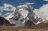
of Voennykh (Army) Topographers(6873 m, 22,550 ft). Peak Voennyh
(Army) Topographers was named after the cartography expedition held
in the region by USSR army topo service in 1943. This expedition
has contributed a lot into cartography of the region, it also has
discoveredc Pobeda Peak (7349 m, 24,111 ft) - the highest mountain
of Tien-Shan.
Terms of the expedition
- July - August 2004.
The head of the expedition-
Juliy Anatoliy Vladimirovich
The team's members:
 Juliy
Anatoliy Vladimirovich, the head of the expedition Juliy
Anatoliy Vladimirovich, the head of the expedition
 David
Lehtman - the participant and the head of more than 30 campaigns
of 5-6 category graded in Pamir, Tien-Shan and other areas. David
Lehtman - the participant and the head of more than 30 campaigns
of 5-6 category graded in Pamir, Tien-Shan and other areas.
 Vladimir
Leonenko All three of them participated in the first expedition
in Chinese Tien Shan in 2002. Vladimir
Leonenko All three of them participated in the first expedition
in Chinese Tien Shan in 2002.
 Jury Strubtsov - a campaign 6-th category graded in Tien Shan, 2001
 Alexey
Kirienko - climb of Barrier pass, ascents on Khan Tengri, Pobeda
peaks, a campaign 6-th category graded in Tien Shan, 2001. Alexey
Kirienko - climb of Barrier pass, ascents on Khan Tengri, Pobeda
peaks, a campaign 6-th category graded in Tien Shan, 2001.
 Ilya
Mikhalev - several campaigns in Pamir, Tien-Shan, a campaign 6-th
category graded in Tien Shan, 2001, ascents on peak Pobeda, Khan
Tengri, peak Communisma, Korzhenevskoy, Mac Kinley etc. Ilya
Mikhalev - several campaigns in Pamir, Tien-Shan, a campaign 6-th
category graded in Tien Shan, 2001, ascents on peak Pobeda, Khan
Tengri, peak Communisma, Korzhenevskoy, Mac Kinley etc.
Sponsors:
"Alpine
-Trade": Tel: +7 (095) 788-1248, Fax: 786-4106. Address: Russia,
105037, Moscow, Pervomaiskaya street, 18, str. 1 - Technical sponsor
of the expedition. Equipment Petzl, MSR.
Travel
agency "Tien-Shan Travel" tel. +996 (312) 270576, travel@tien-shan.com
Travel agency "Association of travellers"
("AsTravel") - visa support.
 Photos
of Pobeda Peak and peak of Army Topographers from the China area
Photos
of Pobeda Peak and peak of Army Topographers from the China area
A journey to a lost
world or out-of-the-way of Chinese Empire. The Expedition “Unknown
Tien Shan” |
EXPEDITION
to "the wild world"
Russian
News:
|
(27.07.2004)
new!
25.07 19-30
Anatoly Dzhuly reports:
11.07.04 - we left on the ridge that we had to traverse
in the first part of the expedition. The altitude was 5200m.
The ridge with the top 6435m actually lasts from Pobeda Peak.
12.07.04 - we made traverse of the first top (5550 m), made
5 pitches and spent 7 hours. Weather was rather good.
13.07.04 - we made traverse of the second top (5620 m), 6,5
pitches, four of them appeared very difficult. Weather became
to worsen. From time to time it was snowing.
14.07.04 - we made traverse of the third top (5650 m) and
climbed some cornices. Weather was bad, visibility was close
to zero.
15.07.04 - we had a forced rest because of very bad weather.
16.07.04 - weather was still bad, but we were able to climb
under the peak 6050, that took 5 hours.
17.07.04 - a rest day again, it was heavy snowing. At spending
the night place snow cover reached up to 1.5 m. Avalanches
collapsed everywhere around. And one of them was on the brink
of our camp. Fortunately, everything practically turned out
all right (we lost only one ski pole).
18.07.04 - bad weather and strong snowfall lasted. We decided
to have one meal and only 200 g gasoline a day.
19.07.04 - the situation was the same. A rest day again. But
that must come to end some day!!!
20.07.04 - rare gleams of light appeared in the sky. We went
the ridge heading the 6435 peak. Having made 6 pitches we
set the camp to spend the night at 6200 m.
21.07.04 - it was the first day of good weather! We went on
the route at 12.00 and already at 14.00 we reached the summit
of 6435 peak! Then we descended to the Plato (Plateau) pass,
that we already climbed in 2002.
22.07.04 - we began to descend from the ridge. Weather was
good, but a strong gusty wind blew. It was high avalanche
danger (for all these days of bad weather snow had piled up
to 3m), therefore we had to choose the way very carefully,
leaving on more difficult, but more safe relief. We descended
to the saddle of the Bozhya Korovka (Ladybird) pass, also
gone in 2002. But having rappelled 7 difficult pitches we
had to make the other way now. For a day we reduced 1600m
of altitude. In total while traversing the ridge we made more
than 40 pitches.
23.07.04 - in the rain with snow we returned to the base camp.
Having given us incomplete two days to finish traverse of
6435 peak and to descend, the good weather disappeared again.
24.07.04 - a rest day in the base camp and discussion of the
further plans.
25.07.04 (today) - in view of two participants feel unhealthy
after such complex and long traverse, where we had more to
sit out and dig out, than actually to go further, and in view
of the developing weather conditions, lost days and etc. we
had to make the hard decision to postpone traverse of Voennykh
Topografov (Military Topographers) peak and to finish our
expedition...
Tomorrow we will leave the base camp and at good transport
joinings on July 28 - 30 we will be able already to be in
Moscow.
Actually - no one of the participants does not regret about
the gone route and about the accepted decision - we have done
a very beautiful and difficult traverse, first ascent the
6435 peak. In general, we will arrive soon and tell and show
you everything.
All of successes and good weather to you!
|
|
|
|
(22.07.2004)
21.07 21-30
Anatoly Dzhuly reports:
We were late making traverse when climbed Kashkar peak
(6435m). It appeared more difficult, than we thought.
Having made 40 pitches we finally summited Kashkar today and
descended to 5600m. We trained to use only 200g gasoline a
day. In 2 days we will descend to the base camp and we inform
you details from there.
|
|
|
|
(6.07.2004)
3.07
Anatoly Dzhuliy reports:
We are on a saddle at 4460 m (14,630 ft) right now.
We've named this pass Kichik-Teren (Kichik means Small in
Kyrgyz language), following the name of the glacier which
we will follow on our descend. The pass is very easy, 1B grade
(climable almost only on foot, minor belay). Everyone feels
bad because we've just started acclimatization.
From the pass we have looked at South pillar of the peak of
Army Topographers (6873 m) - our future route. There
is a few snow this year (most of our way to pass 4460 m was
by talus), so the pillar looks now primarily rocky. So
will see what's there as soon as we will start to climb the
pillar.
|
|
|
|
(2.07.2004)
1.07
Anatoly Dzhuliy reports:
Today in the afternoon our caravan reached the place where
the base camp will be settle. This year the caravan drivers
(local Chinese Kirghiz) appeared especially smart lads
- the group had to hardly run after them. But we got the final
place very fast. We were going to set the base camp at that
camp site where the base camp of our previous expedition in
2002 was, but now we could not find any water there. Apparently,
we have to set it hardly above. And already tomorrow we plan
to leave to the glacier.
Weather is not good yet (it is not necessary the weather to
be good for a while), but there are some shaft of sun light
in the clouded sky.
We were very lucky to find unexpectedly our last year full
carry, practically untouched (in 2002 they finished the campaign
hardly before the planned time and left through other valley).
Such our greetings to ourselves.
|
|
|
|
(1.07.2004)
29.06
Anatoly Dzhuliy reports:
Everything is all right - yesterday early we arrived in
Aksu (through Urumchi), today already have reached practically
merge of Chon and Kichi Terensu rivers, altitude 2400
m. Further we will go with a caravan and if everything is
in the order, the day after tomorrow we will reach the Base
camp.
|
|
|
|
(16.06.2004)
So, the route is finally determined and we will depart
at the end of June. Then we will get to the mountains
first by vehicle, then by a caravan of horses. And at last
we will be able to accomplish the first stage of acclimatization
that will solve two problems: to make first ascent of a new
not high (about 4700m) and not complex (2Ŕ-2B) pass leading
to the next glacier to the east, and to do the first full
carry on the final part of the route. This first stage, from
the beginning of a foot part with horses, will take 8 days.
|
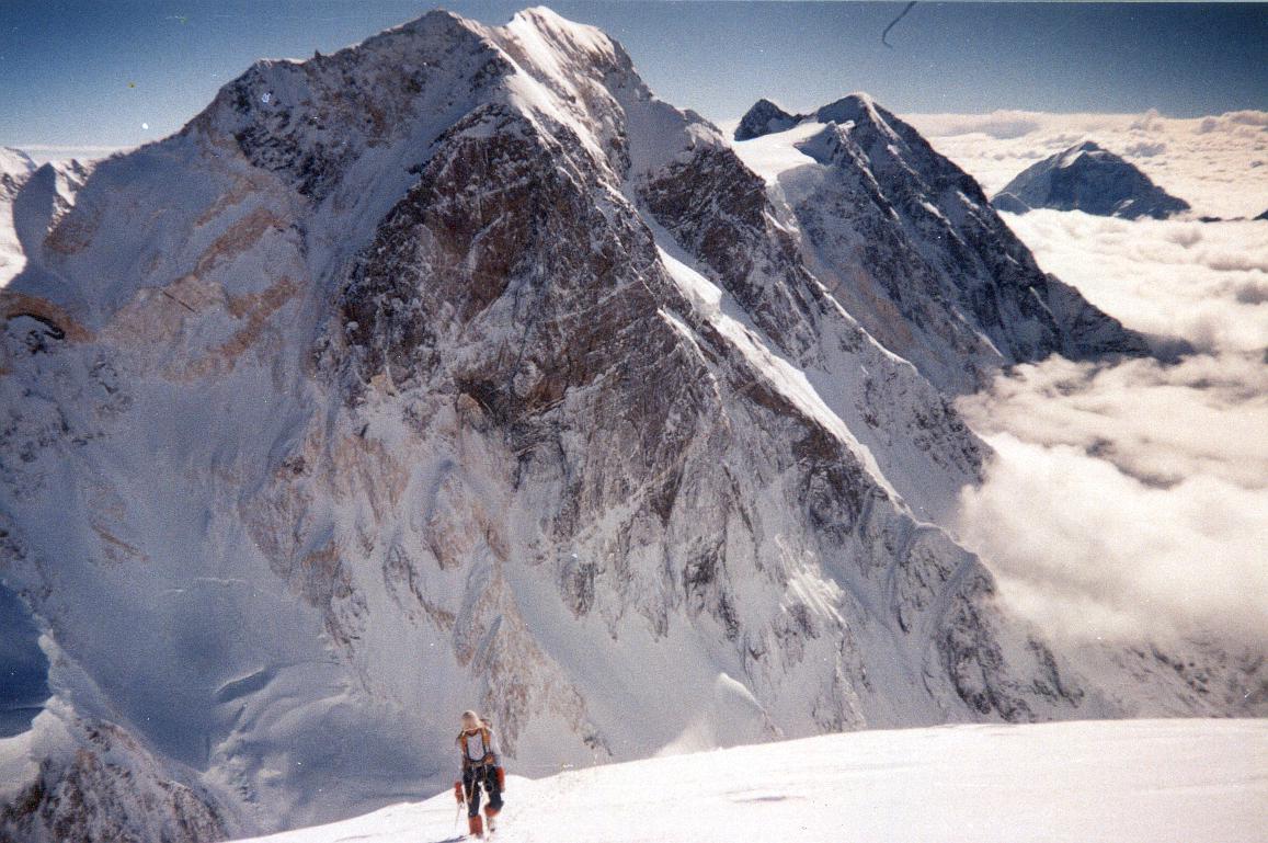
Koshkar, 6435m… The snow ridge
- one of the variants of ascent…
|
The second stage of acclimatization is planned
to take approximately 10 days and consists of first ascent
on Koshkar peak (in my opinion the Chinese call it like so).
Koshkar (6435m) towers separately in plexus of mountains in
a southern spur of Pobeda peak - it is a good altitude to
prepare the next ascent on Voennykh (Army) Topographers
peak. If weather does not disturb our plans, we also will
scout route variants to get to Temirsu glacier for the future
expeditions to the area.
And after having a rest in our
base camp we will start the basic part of our route - to climb
a southern ridge of Voennykh Topographers peak, which should
lead us in upper Southern Inylchek glacier. Then our plans
become rather uncertain and depend on losses of time and forces.
6-10 days are planned to ascend the basic part of the ridge.
Further two variants are possible: to climb a new pass to
the north of Rapasova peak leading in upper Tugbelchi glacier
and to climb Tugbelchi pass already familiar to us and finally
to get to our food and gear on Kichikteren glacier carried
earlier or to make a "big ring" through Inylcheksky pass,
one new pass from Tugbelchi glacier to carried food and gear
on Kichikteren glacier.
|
|
|
|
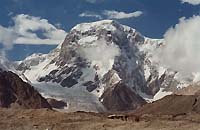
Voennykh (Army) Topographers peak
en face and in profile. In profile you can see our ridge
- the second one. The crux of the route is a rocky belt
at 6000-6300m. There is one more a bit easier crux a
little higher, somewhere at 6500-6700m. Our further
route depends very strongly on amount of the days we
need to climb this top part of the ridge…
|
And the final part of the route assumes
route's reco to the east from Kichikteren glacier. We plan
even a week on trekking over inflows of the glacier. After
one and a half of month in the mountains our expedition will
get to the end by this moment. Then we will make a planned
trip to the coal-mining combine.
It is difficult to assume what will we
really be able to realise. Tien Shan is a very whimsical area
|
|
|
|
(1.04.2004)
In the summer, 2004 a team led by Anatoliy Juliy plans
the second expedition to Central Tien Shan mountains (the
area of peak Tomur - peak Pobeda) from the China part.
For today, in our opinion, it is one of the most remote and
scantily researched mountain areas, which have stayed on our
planet. Our first expedition in 2002 allowed to make researches
with the object of sports opportunities of several glaciers,
opportunities for passage of new passes and making new ascents.
The purpose of the second expedition is passage several
new still unclimbed passes, first ascents on one or two "6-thousand"
mountains and an ascent via a new route from the south on
one of known summits of Kokshaaltau ridge - peak of Voennykh
(Army) Topographers.
Terms of the expedition - July - August 2004.
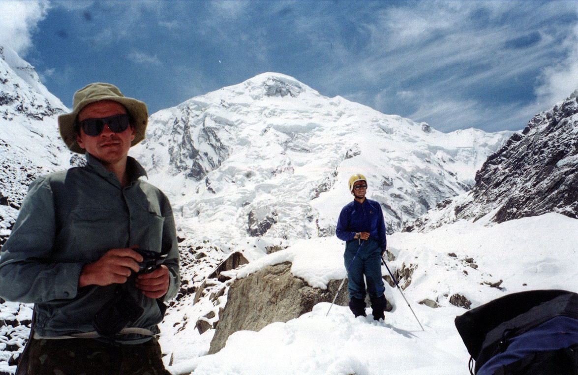
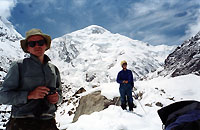
Structure of the team: 6-10 person. Juliy Anatoliy Vladimirovich
- the head of the expedition. All participants have an
experience of high-altitude ascents and an experience of sports
joint campaigns and expeditions under my leadership.
We are going to make video and photo shooting about the expedition's
work.
The cost of the expedition on 8 person is approximately
16000 dollars. Taking into account the certain financial difficulties
at the majority of the participants, we ask to consider the
problem of sponsor's support. We are ready to accept any
help - financial, maintenance with equipment, products, including
an opportunity of purchase of necessary gear with the greatest
possible discount .
Tel. 922-3621, +7 (095)
708-7779, e-mail: anatolii@ultranet.ru
|
|
|
|