При вводе Логина и Пароля,
обратите внимание
на используемый Вами
регистр клавиатуры!


|
|
|
|
|
Подсказка
|
||
|
При вводе Логина и Пароля, обратите внимание на используемый Вами регистр клавиатуры! |
||
|
|
|
|
| Добро пожаловать ! | Войти в Клуб Mountain.RU |
 |
|
|
|
 |
|
Mountain photos - amateur
and professional photos of mountains.
|
| Climb > |
|
First ascent of the South-Western face of Mahindra peak, Himalayas, India
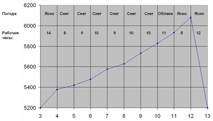
September 3 – 13 2008
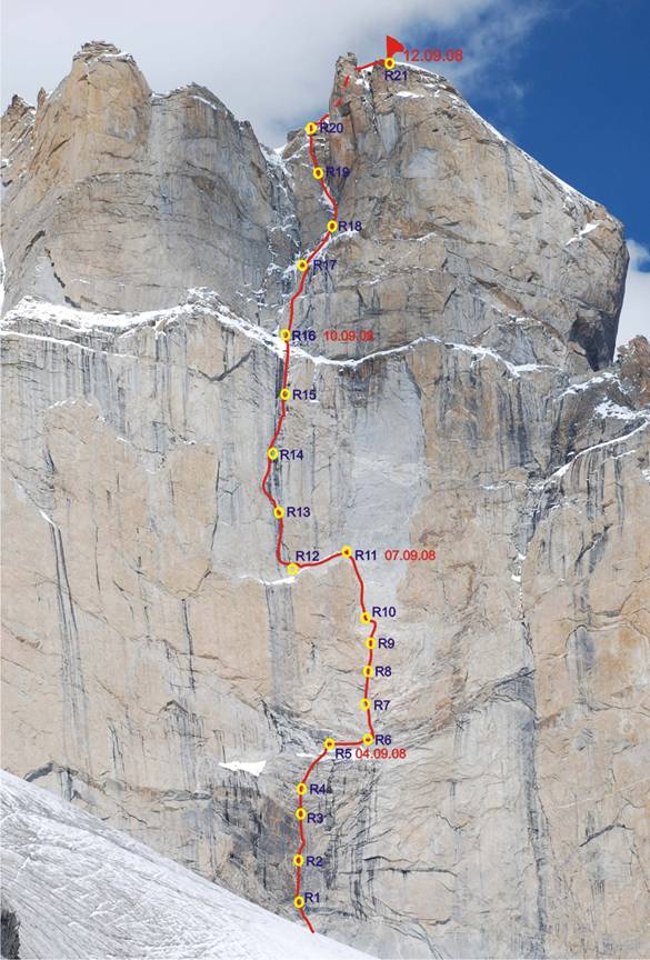
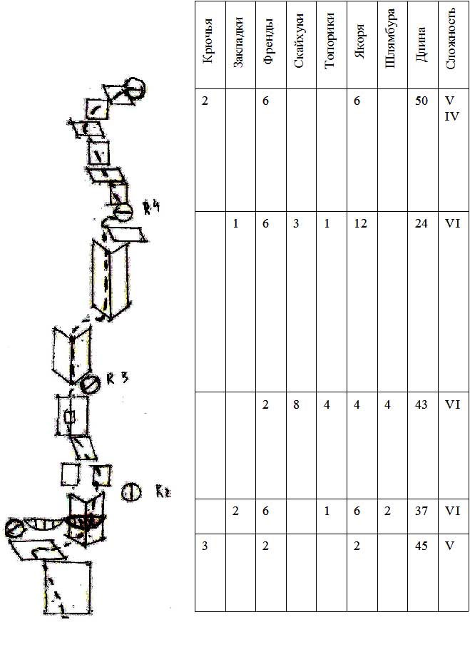
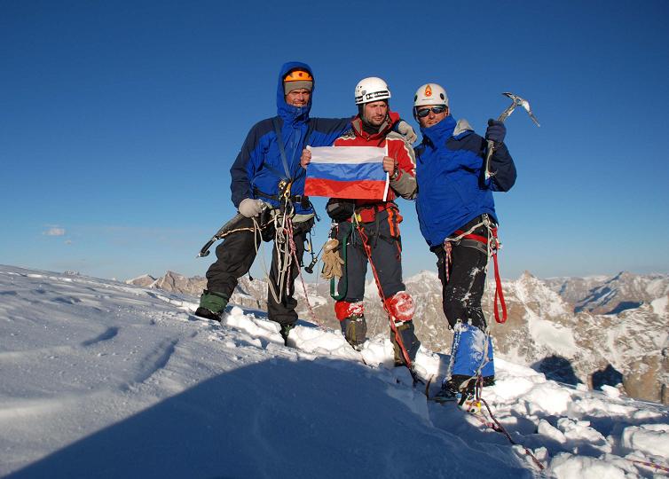
Ascent passport 1. North-Western Himalayas, India , Miyar gorge, Eastern ridge. 2. E. Mahindra South-Eastern along the central part of South-Western face. 3. Estimated grade is 6B. 4. Route type: climbing 5. Altitude difference: about 880 m (5200 – 6080). Length: 1077 m, Average steepness of wall part of the route - 80° Average steepness of the route – 76° Bolts – 49, AID 45 Nuts – 30, AID 24 Schlagbohrers – 26, AID 4 hatchets – 22 Kochetkov Grigoriy Sergeevich – Master of sports. Vlaznev Dmitry Alexandrovich – Candidate to Master of sports. 9. Trainer: Korol Eugene Mikhaylovich – Master of sports. 10. Start of the route: 5:00, September 3 2008.
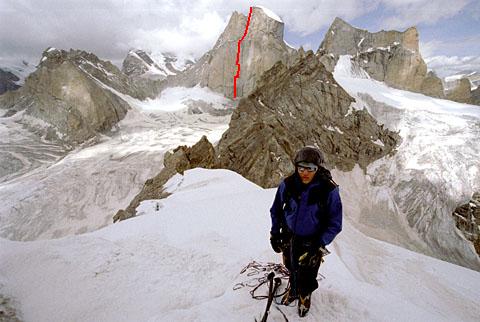
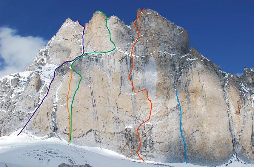
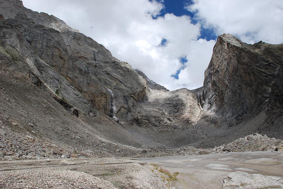
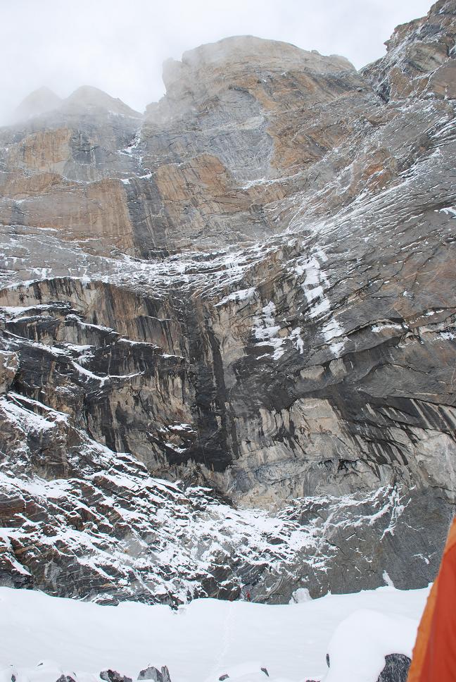
The South-Western face of Mahindra peak on the left and right sides is pressed by vertical ridges, that's why you can make photo of the wall side-view only from one of the nearest summits. We couldn't make such an ascent because of the restricted terms of our expedition. We give a photo made by Polish expedition of 2006. The South-Western face of Mahindra peak is seen on the background. Route line is marked by red coulour.
Average steepness of the route – 76° Average steepness of the wall part – 80°
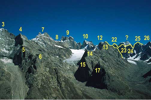
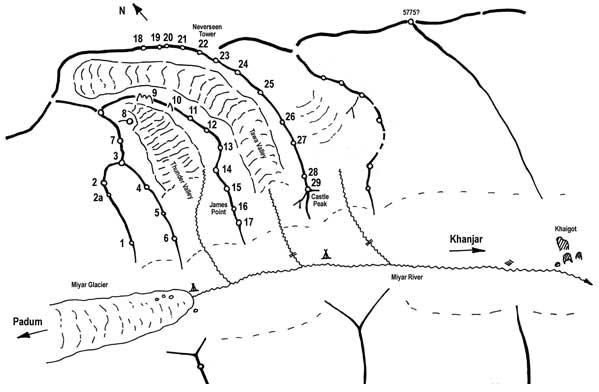
Explanation to photo panorama 1 – Small «Shamoni» tower, 4 – summit with a «window», 7 – double summit, seen from the Base Camp, 8 – summit with a snowy plateau, 9 – Mahindra, 6080m, 10 – Grome peak (Thunder Peak), 5990m, 12 – Veneto Peak, 5850m, 14 – yellow wall (from the glacier Grom side), 15 – «big» wall near the step of glacier Grom, 16 – James Point, 17 - «small» wall near the step of glacier Grom, 19 – Paola?s Peak, 20 – peak 5700 m, 21 – peak 2725 m, 22 – Neverseen Tower, 29 –Castle Peak, 5700m. Altitude is given for the peaks where it is known .
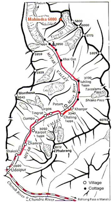
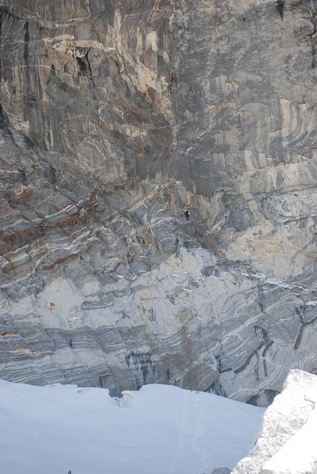
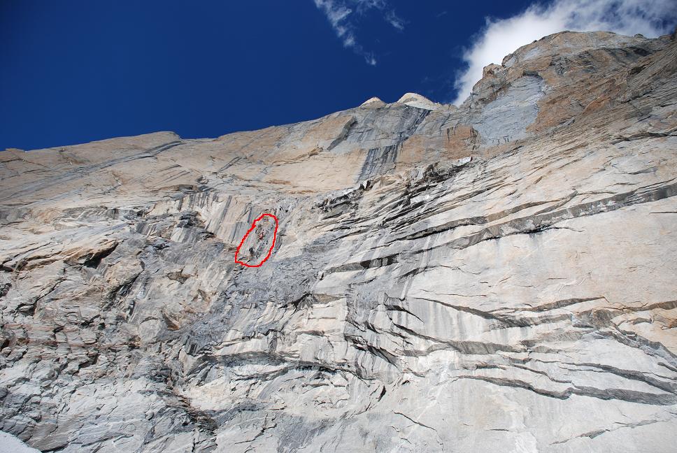
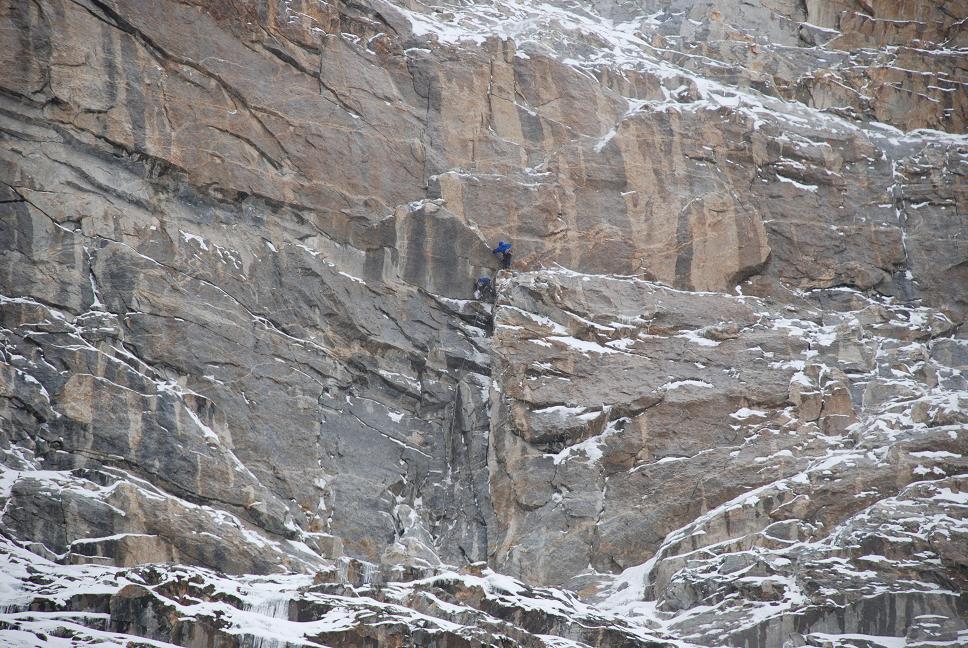
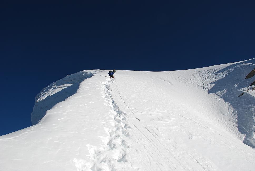
Miyar valley is located in the northern part of the Indian state Himachal-Pradesh in Lahul area, to the north from Udaypure city. Total length of the valley is almost 100 km. In the lower part of Miyar valley there are two well-known 6000: Phabrang 6172m, and Mentoza, 6443m – the highest peak of the region. Most of the ascents in the upper part of Miyar valley were made in two neighboring gorges - Thunder valley and Tawa valley. Base camp is near the entry to the gorges on 3950 m, near the beginning of Miyar glacier, in 40 km from Tingrat village. One can reach Tingrat from Manali by regular buses or jeeps. From Tingrat to base camp one can ride a horse (2-3 days). The significant merit of the Italian expedition with Paolo Vitalio in 1991 is the discovering of the upper part of this region, containing fantastic facilities for rock climbing, which can be compared only with Trango region. Paolo didn't have any information except one small photo with little area of rock on it. The expedition efforts were directed to the exploration of Tawa glacier and firstly to the ascent of famous in future Neverseen Tower . Next year second Italian expedition with Massimo Marchegiani as a leader arrived in the region and made several ascents. Participants of this expedition, Diego Stefani and Janluka Bellin saw the huge vertical wall of South-Western exposure which later was named Mahindra peak (local name is Jangpada which can be translated as “lifeless mountain”). They were the first who approached the wall. The South-Western face of Mahindra peak locks up Thunder glacier. Its foot lies in 10 km from the base camp with altitude difference 1300 m. Glacier Grom in its lower part breaks with vertical boulges (altitude difference about 400 m) fixing lines up is needed in several points. These factors make the South-Western face of Mahindra peak hard-to-reach. Light approach to the foot of the wall takes about 6 hours, with luggage it takes 9 hours (for acclimatized person). The North-Eastern face of Mahindra peak – from the side of Tawa glacier – is rather destroyed. The North-Eastern face is hard-to-reach because of its remoteness – more than 15 km through the glacier. That's why all the tries of ascents to Mahindra peak were made from the side of glacier Grom. From the moment of discovery several unsuccessful tries to ascend the Mahindra peak were made. The first try which can be called successful was made by the Slovaks Dodo Kopold and Ivan Stefansky (to the North-Eastern face, route “In the last moment”) – they didn't pass only last 100-150 m. They called the mountain Mahindra. The first ascent – to the central summit- was made by the Americans Dave Sharatt and Fred Wilkinson on September 3 2007. All the tries were made along the edges of South-Western face of Mahindra peak. Before our expedition there were no tries to pass The South-Western face of Mahindra peak along its central part because of the abruptness and difficulty of this section of the face. In 1998 the Mahindra peak was considered by the participants of the project “Russian way – worlds' mounts” as an alternative to Bhagirati peak. The South-Eastern peak remained unsubdued until our expedition. Photo of the wall with route lines and ascend tries
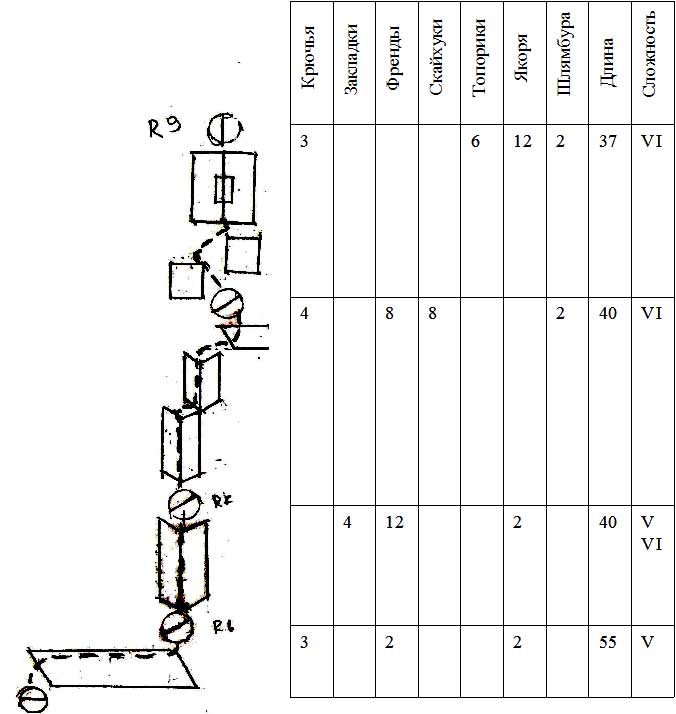
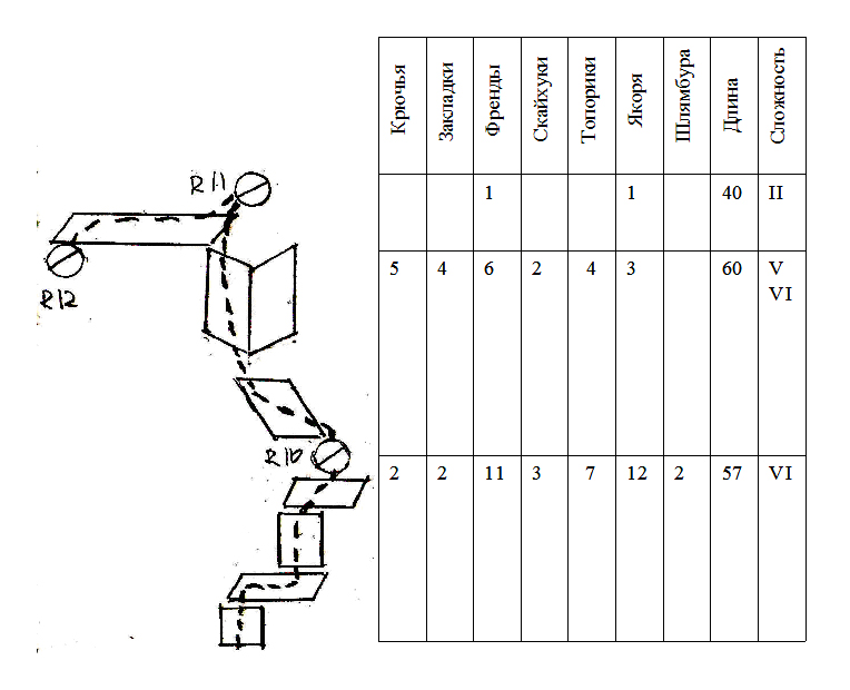
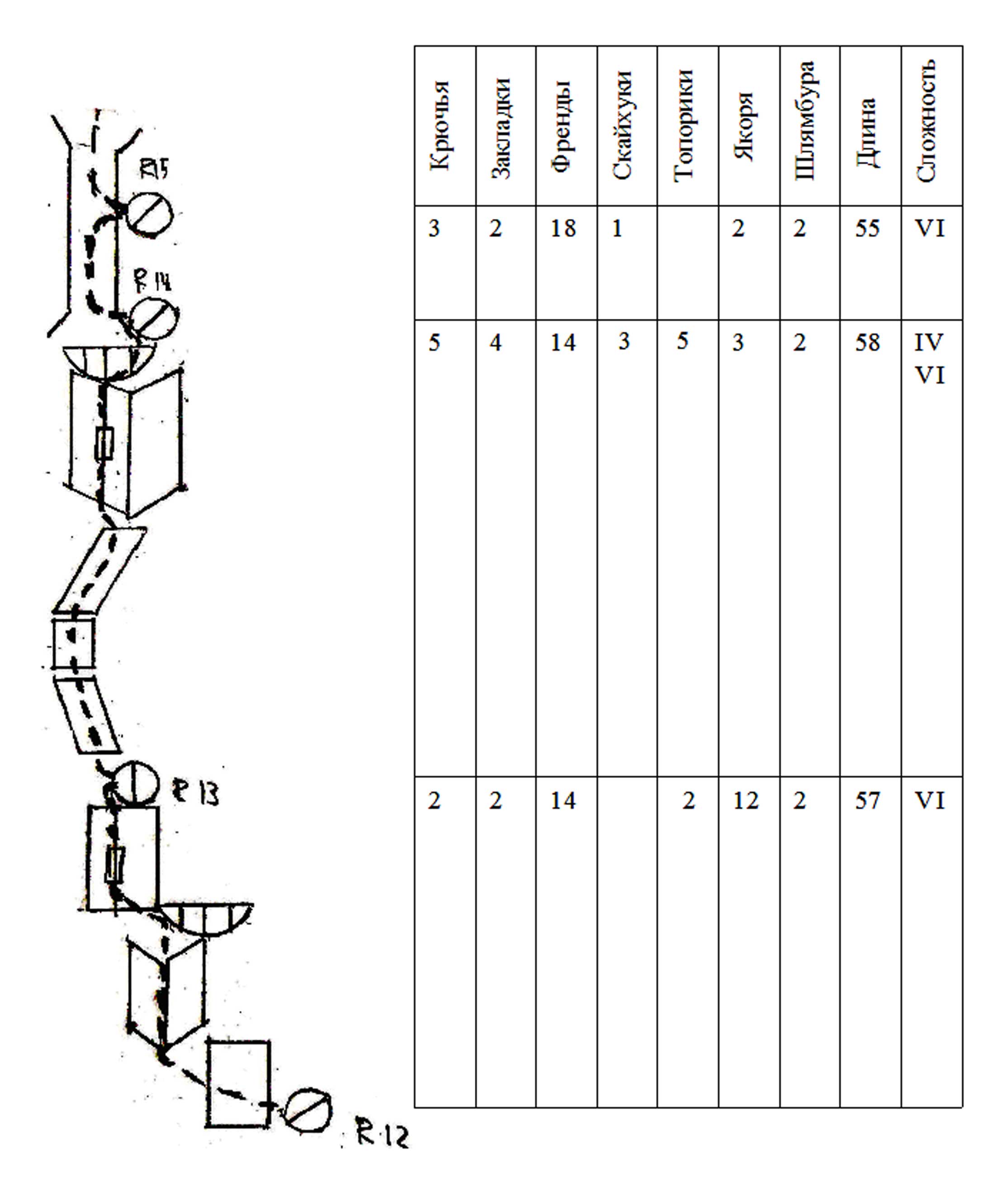
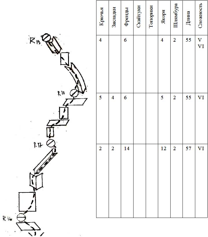
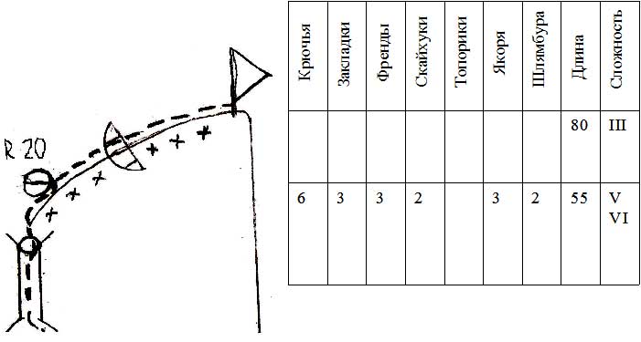
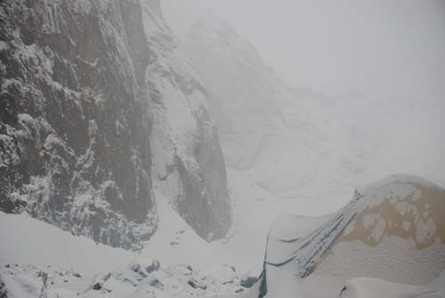
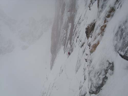
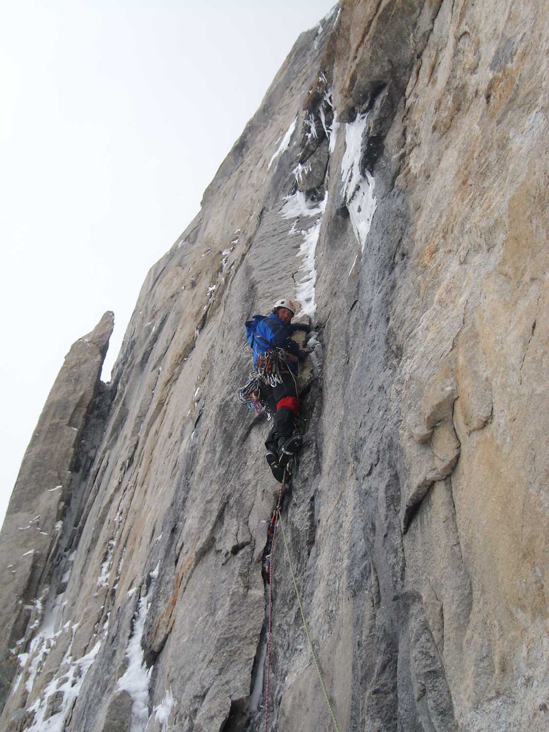
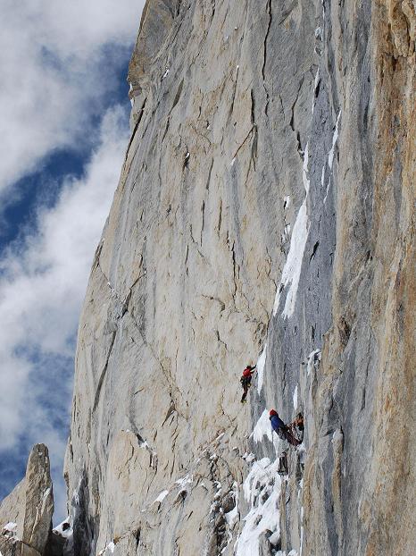
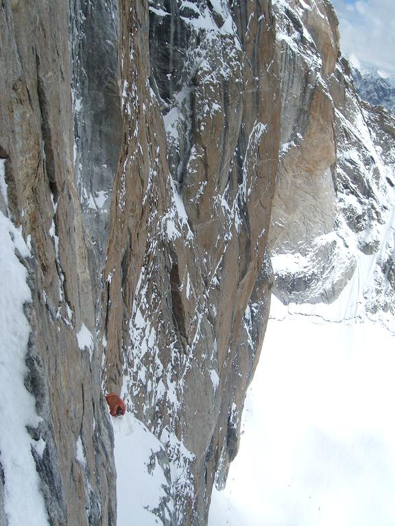
R0-R1 Go to the implicit wide inner corner by the destroyed rocks to the overhanging red wall, 45 m, V, 70°. R1-R2 Traverse to the right and upwards 7 m, V, А 3, 85°, then go upwards 30 m, VI, А 3, 95°, anchors, holes, bolt. R2-R3 Go to the right and upwards to the beginning of the implicit wide inner corner 20m, VI, А 4, 100° along the cracks, with sky hooks, then go along the implicit inclined ledge to the left and upwards 5m, А 2, VI,90°, then there is a crack to the right and upwards 7m, А 4, 100°, sky hooks, bolts, then go 15 m upwards VI, А 3, 90° to the ledge. R3-R4 Inner corner with wide crack, 7 m, VI, А 3,85° traverse to the right 2m, a vertical inner corner, 15m, VI, А 3, 90°. R4-R5 Through the system of frozen boulges 15m, V, 75°, then boulges become more inclined, go to the ledge via ice 35m, IV, 50-60°. R5-R6 Traverse to the right along the ledge on snow and ice 50m, II, 40°, then to the right and upwards under the rocky wall 5m, V, 80°. R6-R7 Traverse to the right 8m, V, 80°, then go upwards through the rocks and ice to the inner corner, which opens to the left, with vertical crack system, 10m, V, 75°, then go upwards along the right side of the corner, through the cracks filled with ice 30m, VI, А 2, 95°. R7-R8 Go through big breaks and wandering ice, along the right side of the corner, to the foot of big vertical slab 40 m, VI, А 2, 90°. R8-R9 Go to the left and upwards along the narrow crack 7m, VI, А 3, 75°, then to the right and upwards along the narrow disappearing crack with hatchets and sky hooks, 30 m, VI, А 4, 85°. R9-R10 Go upwards along the moving ice-bound unit, then go upwards along the right crack in the slab, 15 m, VI, А 3,90°, then go upwards on sky hooks along the slab 8m, VI, А 4, 85°, then go upwards through the system of blocks, covered with ice 20m, VI, А 2, 85°, then on wandering ice 10m, V, 60°, to the ledge on the foot of gray slab. R10-R11 Go to the left and upwards along the inclined ledge, covered with snow on ice-covered rocks, 10m, V, 60°, to the left side of the large corner, leading to the 2 nd ledge, leaving gray destroyed wall on your left, 35m, VI, А 3, 90°, then go upwards through the system of blocks, covered with ice, to the ledge 15 m, V+,75°. R11-R12 Go to the left along the snow-covered ledge along the gray destroyed slabs to the beginning of black flashes. 40m, II. R12-R13 Go to the left and upwards along the crack 7m, VI, А 2, 95°, then go vertically upwards along the crack turning into the inner corner 25 m, VI, А 2, 85°, bypassing on the left the cornice with ice, then go upwards along the narrow crack to the beginning of the inclined snow-covered ledge, 30m, VI, А 2, 80°. R13-R14 Go along the inclined ledge to the left and upwards 7m, IV, 50°, then go to the left and upwards along the wide crack to the nail wall, 8m, VI, А 2, 65°, then go upwards through the slab on sky hooks, 5m, VI, А 4, 85°. Go along the left side of the wide inner corner, along the narrow crack on anchor bolts, traversing the overhang to the right, 25m, VI, А 3, 90°. Then go to the right and upwards, to the right wall of the wide inner corner to the beginning of the big chimney 12m, V, 75°. R14-R15 Go upwards through ice-covered rocks in the big chimney, on big blocks and a system of big cracks 55m, VI, А 3, 90°, belay is on the right, on the slab. R15-R16 Go upwards through the slab on sky hooks 5m, VI, А 4, 85° then go upwards through the widening chimney 20m, V, 80°, then through the ice-covered ledge go upwards 25m, II, 50°. R16-R17 Go to the right and upwards along the wide crack 20m, VI, А 2, 90°, then go along the crack to the left from the inner corner 7m, VI, А 2, 80°, to the right and upwards through the inclined inner corner 30m, V, 80°. R17-R18 Go upwards through the ice-covered slabs to the beginning of big ice-covered couloir on the left under the peak bastion 55m, VI, А 2, 70°. R18-R19 Go upwards along the couloir on ice and ice-covered rocks 35m, V, 70°, then through the rocks and wandering ice to the beginning of the vertical chimney 25m, V I , А 2, 75°. R19-R20 Go upwards through the chimney (difficult gymnastically climbing with AID and sky hooks 35m, VI, А 2- А 3, 90°, then on ice and rocks go to the bridge 20m, V, 70°.) R20-R21 По острому снежному гребню вверх, через ледяной карниз-наддув, выход на вершинный купол 80м, III , 40-70°. Tactical actions of the team Our team decided to pass SE face in its most difficult and long central part. Besides high technical grade the central part of the wall is attractive with ledge system and snow on it, which allow passing the wall without using platforms – from ledge to ledge, and not to bring water it is especially important on altitude with negative temperature. In the lower part of the wall the route was chosen through the implicit inner corner to the center of the 1 st ledge. This way is the most logical one, because it goes between large cornices on the right and on the left, practically avoiding overhangs. The line between the 1 st and 2 nd ledges was chosen from the right side of the ledge, because the relief in the central part was poor. Moving in the right section of the 2 nd ledge was estimated to be dangerous because of destroyed rocks (a well seen gray spot to the right from the 2 nd ledge). Thus the route was chosen along the black flashes in the central part of the ledge, then turning into the wide ice-covered chimney. Then this chimney goes to the bridge between the Central and SE peaks. In the meantime, because of the narrowness and western exposition, the chimney is sunlit between 5-7 PM, so it isn't dangerous with rockfall connected with melting. According to the information from the locals, this year precipitation was record for recent 30 years in the Lahul and Spiti regions, where Miyar valley is located. Short windows alternated with long periods of bad weather. The team spent several days under the wall waiting for the weather. During first sunny day the section till the first ledge was passed, and an opportunity to move the camp came. In subsequent days the weather was bad again or very bad. That means sun in the morning during 2- 3 hours, but in 12 AM clouds came and snowdrift began. Since the length o the route and total uncertainty with the weather, we decided to work in any weather. An additional fact was the information about the competing team of Korea who also planned to ascend to the SW peak of Mahindra and set up acclimatizing camps. As a result, the team worked every day, even in hard snow. No one from the team hasn't ever worked on route of this grade in such weather. Long bad weather considerably hardened the ascent. The team worked on the limit of their physical abilities. Grigory Kochetkov decided to descend on the 2 nd day because of his health, and Dmitry Vlaznev didn't go to the summit on the day of summit push. Photo illustrations
|
| Поделиться ссылкой |
|
|
| © 1999-2007 Mountain.RU Mail to: info@mountain.ru |
|